Cahir Castle
For a castle whose island, walls and towers still work as a single defensive system.
The story behind Cahir Castle
This thirteenth-century stronghold occupies rock in the River Suir. The Butlers developed it into a substantial fortress, later attacked by the Earl of Essex in 1599. The water is part of its architecture, not simply a picturesque background.
What you will see
Explore the enclosing walls and keep, then use the audiovisual presentation to put the siege and later alterations in context. From outside, walking around the river edge helps explain the shape of the site. The town centre is beside the castle.
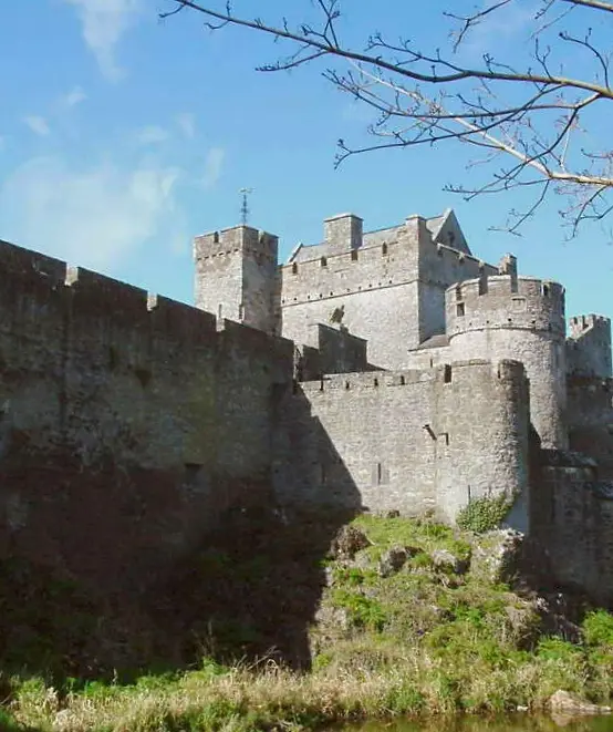

Resized and converted to WebP. Display may be cropped; the full photograph is linked.
Ticketed admission
Adult admission is €5. September to mid-October hours are 09:30 to 17:30, last admission 16:45; shorter hours follow in winter. The published annual closure includes 24 to 30 December. Groups should book. Expect uneven surfaces and stairs; nearby public parking is available.
Check the official visitor information ↗Sources and checks
- Office of Public WorksVisitor access and historical context. Checked .
- Fáilte IrelandHistorical context and visitor experience. Checked .
- Kind
- Castles
- Nearest road
- Castle StreetThe closest named road, measured here. The map records no address for this place, so this is not a statement about where its door is.
- From the centre
- 190 m west, in a straight line
- Run by
- Office of Public Works
- Wheelchair
- Recorded as partly accessibleOne tag covering the whole place. It does not say whether the entrance, the inside, the toilets or the route to the door are step free, and this page will not say so either.
- Dated
- 1142
- Parking
- Castle Street Car Park, 50 m away
- Bus stop
- Unnamed stop, 70 m away
The map does not yet record a phone number for Cahir Castle. Anyone can add it on OpenStreetMap, and this page picks the change up at the next refresh.
Getting to Cahir Castle
About these directions
Public transport times come from National Transport Authority. Timetables cover 2026-09-18 to 2027-09-19. These are scheduled services; check with the operator for cancellations and changes before travelling.
Walking and driving times are estimates. A town search starts at its centre; choose your location or a point on the map for a more precise starting point. Eircode search is not available.
How journey planning worksDestination, access and nearby stops
Cahir Castle is in Cahir, County Tipperary. Routes here end at the point the map records for this place. No entrance has been verified, so the last few metres are for you to judge. Castle Street Car Park is 50 m away and the map records it as open to the public.
The nearest scheduled stop is Cahir Castle (15049), 60 m away in a straight line. Use the planner to check walking connections for your journey.
- Cahir Castle 60 m
bus UC04Scheduled departures from this stop
- Cahir 70 m
buses 55, 245X, 355, 855 and 245Scheduled departures from this stop
- Cahir Stn 540 m
bus 855Scheduled departures from this stop
- Abbey Cres 1.2 km
bus 855Scheduled departures from this stop
Getting to Cahir covers the journeys into the town itself.
Within a short walk
What else the map names within four hundred metres of Cahir Castle, on Castle Street and around it.
- Cahir Castl Reception20 mTicket
- Opening hours and prices50 mVisitor information
- Inch Field50 mParks
- The Butler Trail50 mVisitor information
- Great War Memorial60 mMonuments
- River House60 mRestaurants
Also on Castle Street
Castle Street carries 20 of the places the map names in Cahir.
- Morrissey’sPubs
- River HouseRestaurants
- Castle View CraftsGift shops
- Great War MemorialMonuments
- AIBBanks
- Lava RockRestaurants
- Titanic memorialMonuments
- Fitzgerald'sNightclubs
- O'BriensButchers
- Yummy HouseTakeaways
- Rich RagsClothes shops
- The Lazy BearTakeaways
- The KeepCoffee
- John QuirkeJeweller
- Alla's PatisserieBakeries
- Dónal T. RyanSolicitors
- Shamrock LoungePubs
- Fine CutzBarbers
Other castles in Cahir
Nearest to Cahir Castle first, and the figure beside each one is how far it is from Cahir Castle, in a straight line. Same point, same measure.
- 410 m
- 3.7 km
- 3.8 km
- 4.8 km
- 5.2 km
- 6.7 km
- 6.8 km
- 7.1 km
- 7.7 km
- 7.9 km
- 8.0 km
- 8.0 km
Questions people ask
Where is Cahir Castle?
How do you contact Cahir Castle?
How far is Cahir Castle from the centre of Cahir?
Are there other castles near Cahir Castle?
How do you get to Cahir Castle without a car?
Where this comes from
- From the map
- The name, the kind of place, the address where the record carries one, and any website, phone or opening hours shown as recorded on the map are tags on OpenStreetMap way/162602114, and can be corrected there.
- Worked out here
- Every distance, the nearest road where the record has no address, which car park and which stop are nearest, and the order of the lists are this site’s own calculations from those records. Distances are straight lines between two points, not walks along the footpaths, and the map will route the real walk on request. A mistake in any of this is a mistake here rather than on the map.