Galway, County Galway · on foot · worked out from the map
Galway in a day
A day on foot in Galway: 9 stops the map records, joined in the shortest order that walks them all, 5.38 km in total.
9
stops
6 hr
inside them
5.38 km
walking, along the paths
2
with hours on the map
Make it your Galway day
Start with the city. Leave room for a detour.
A square, then the river
Eyre Square gives you space to get your bearings before following the route through central streets. Around Spanish Arch, the City Museum adds context to the buildings and waterfront. Its admission is free, but check the museum’s opening day before making it the centre of your visit.
This route includes theatres and arts venues. A pin on the route is not a scheduled show or a promise of daytime entry. Check the programme, book a performance you want to see, and remove venues that do not fit your day. The walking connections update when you change the stops.
Leave a gap between the museum and any evening performance. Compare a riverside meal, a pub lunch or a longer tasting menu in the Galway food guide. For music afterwards, choose a session with a published programme if the timing matters to you.
1 hr 7 min of it is walking, 5.3 km in all, along the paths the router followed. The day is kept in this browser only; nothing is sent anywhere.
Drawing the day…
Tap a pin to open its stop. The line is the walk between them.
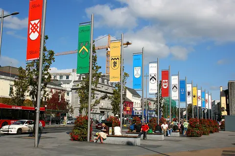
Eyre Square · Eoin Gardiner, CC BY 2.0 via Wikimedia CommonsResized and converted to WebP. The full photograph is linked.
Begin with the open space of Eyre Square before the route moves into narrower streets. The park is also named for John F. Kennedy; its public art includes a fountain inspired by the sails of a Galway Hooker. Use this first pause to decide which indoor stops suit your day.
Visitor information sources
Galway City CouncilKennedy Park location, public access and recreation facilities · Checked 2026-09-23
Galway TourismSquare history, artworks and city-centre setting · Checked 2026-09-23
Each walk is routed over OpenStreetMap footpaths on this site’s own graph, and the minutes are that measured distance at 4.8 km an hour. That is a stated pace on level ground, not a promise about yours or about the hills in the way. Where the router finds no way on foot between two stops, the page says so and draws nothing: no walking time here is worked out from a straight line. Nothing here states an opening time or an admission price unless the map records it, because a wrong one ruins a day in a way a missing one does not: every stop links to the operator instead. Distances are within Galway.
How the day is shaped
Morning
Eyre Square, Town Hall Theatre, An Taibhdhearc and Galway City Museum. 130 minutes in all.
Middle of the day
Galway Arts Centre and Nun's Island Theatre. 80 minutes in all.
Afternoon
James Mitchell Geology Museum, Terryland Castle and The Black Box. 125 minutes in all.
About 6 hours inside the 9 stops, and 5.38 km of walking between them along the paths the router followed. Drop a stop and the walk either side of it is worked out again.
Who chose these stops?
The route connects local points of interest using mapped walking paths. Stop lengths are suggestions: shorten the day or stay longer at the places that interest you. Researched visitor notes, where available, include their sources. The route itself does not confirm that a venue is open or a performance is scheduled.
Are the opening times here?
The map records opening hours for 2 of the 9 stops, and those are shown. For the rest this page says nothing rather than guessing, and links to the place instead.
What does it cost?
This page does not say, because it does not know. Admission is set by each place and changes; nothing here is stated as a price.
How do you get to Galway?
44 bus and train lines call at a stop in Galway in the published timetable. Which of them runs on the day you are going is worked out on the Getting to Galway page, along with the walk at each end.
The order and the minutes were computed on 2026-09-20 by the rules above. Place locations and recorded opening hours come from OpenStreetMap. Researched visitor notes have their own sources linked on the cards. Check the venue for current admission and opening arrangements. Each walk is routed over OpenStreetMap footpaths on this site’s own graph, and the minutes are that measured distance at 4.8 km/h, which is a stated pace rather than a promise about yours.