Trá Saorphort (Bóithrín Mags), Bearna
Trá Saorphort (Bóithrín Mags), Bearna is one of the waters the EPA tests and grades in County Galway, 0.4 km south-east of Barna. The EPA has published no water quality classification for it. The register records no facilities here. It leaves 2 of the questions on this page unanswered, and those are shown as not recorded rather than as a no.
- Water quality
- No classification published
- Water testing
- Tested by the EPA sampled through the season and given a water quality grade
- Season restriction
- Not recorded
- Pollution after rain
- Not recorded
- Awards
- None
- County
- County Galway
- Managed by
- Galway County Council
- Nearest town
- Barna, 0.4 km south-east of it, in a straight line
- From that town
- 0.6 km by road, about 1 min drivingor 0.6 km on foot, about 7 minutes at 4.8 km/h
- Lifeguard
- No
- Toilets
- No
- Parking
- No
- Access
- No
- Dogs
- No
- Cars on the beach
- No
- Public transport
- No
- Position
- 53.2503° N, 9.1457° W
- Record changed
- 2026-02-24
_-_geograph.org.uk_-_1288758.jpg)
_-_geograph.org.uk_-_1288714.jpg)
What the EPA says about it
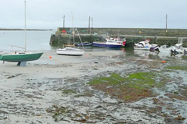
Trá Saorphort/Freeport (Mags Boreen) Beach is situated close to Bearna village centre, which is located circa 7kms west of Galway City. The beach can be accessed from the R336 coastal roadway, via Mags Boreen. There is a public footpath along the full length of this boreen (along the eastern side) which facilitates pedestrian access to the beach. The beach itself is a sandy, moderately sloping beach which faces southwards across Galway Bay. Freeport beach is a sandy (fine to medium/coarse sand), moderately sloping beach, which grades into an extensive, more gently sloping, white sandy platform which is visible at low tide. There are a couple of subsidiary sandy areas located on the eastern side of the main Freeport beach. The main beach area has a gentle curved shape, approximately 110m wide, bounded to the west and east by granite boulders which extend out to sea.
Trá Saorphort (Bóithrín Mags), Bearna has been newly identified in 2024 as a beach for monitoring, management and assessment under the requirements of the 2008 Bathing Water Quality Regulations. Annual water quality assessment has not yet been undertaken.
Where it is
Trá Saorphort (Bóithrín Mags), Bearna, and the other places to swim in County Galway. Share your position and the map will show how far each one is from you.
Getting to Trá Saorphort (Bóithrín Mags), Bearna
About these directions
Public transport times come from National Transport Authority. Timetables cover 2026-09-18 to 2027-09-19. These are scheduled services; check with the operator for cancellations and changes before travelling.
Walking and driving times are estimates. A town search starts at its centre; choose your location or a point on the map for a more precise starting point. Eircode search is not available.
How journey planning worksDestination, access and nearby stops
Trá Saorphort (Bóithrín Mags), Bearna is in Barna, County Galway. Routes here end at the point the map records for this place. The entrance has not been verified, so the last few metres are for you to judge.
The nearest scheduled stop is Bearna (530711), 240 m away in a straight line. Use the planner to check walking connections for your journey.
- Bearna 240 m
buses 424 and 525Scheduled departures from this stop
- An Cimín Mór 1.9 km
buses 411, 412 and 410Scheduled departures from this stop
- Páirc na Ceapaí 2.0 km
buses 411, 412 and 410Scheduled departures from this stop
- Tor Buí 2.2 km
buses 411, 412 and 410Scheduled departures from this stop
- Sruthán Thiar 2.2 km
bus 402Scheduled departures from this stop
Getting to Barna covers the journeys into the town itself.
Other places to swim in County Galway
- Aillebrack/Silverhill Beach
- An Trá Mór, Coill Rua, IndreabhánBlue Flag
- An Trá Mór, Gorumna Island
- Ballyloughane Beach
- Bathing Place at PortumnaBlue Flag
- Céibh an SpidéilBlue Flag
- Cill Mhuirbhigh, Inis MórBlue Flag
- Clifden Beach
- Dog's Bay, Roundstone
- Dumhach
- East End Inisbofin
- Glassilaun, Killary
- Goirtín, Cloch na Rón
- Grattan Road Beach
Questions people ask
Is the water clean at Trá Saorphort (Bóithrín Mags), Bearna?
Is swimming restricted at Trá Saorphort (Bóithrín Mags), Bearna?
Does Trá Saorphort (Bóithrín Mags), Bearna have a Blue Flag?
Is there a lifeguard at Trá Saorphort (Bóithrín Mags), Bearna?
How do you get to Trá Saorphort (Bóithrín Mags), Bearna without a car?
Where does this come from?
Water quality, awards, lifeguards, toilets, parking and access are the Environmental Protection Agency’s own fields, from its bathing water register, read 2026-09-20. The classification covers four years of sampling and is not a reading for today: after heavy rain the water can be worse than the classification suggests, and the EPA and the local authority post notices when it is. Positions are the EPA’s grid references, projected to latitude and longitude. Journeys are the National Transport Authority’s published timetable.
Beaches and bathing waters in Ireland·Beaches in County Galway