Mountcollins, County Limerick
Things to do in Mountcollins
Find places that fit your time and your plans. 1 of them is in Mountcollins itself and 31 more within twelve kilometres, because the castle outside the village is usually the reason to go to the village.
32 places
Places to explore in pictures
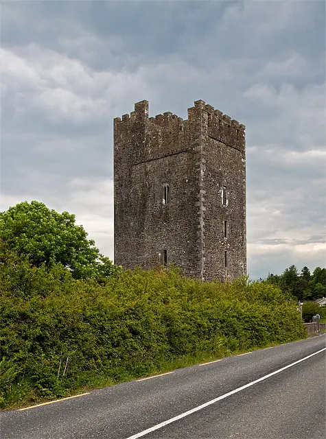
Mike Searle · CC BY-SA 2.0. Via Wikimedia Commons. Resized and cropped for display.

More places to explore
- Holy wellsTobernanoon960 m from the centreOutdoors · About 15 min
- Ringforts and sitesCaherleboy2.1 km east of MountcollinsOutdoors · About 20 min
- Picnic sitesThree Counties2.3 km south-east of MountcollinsOutdoors
- Ringforts and sitesCaheradawpogh2.4 km north-west of MountcollinsOutdoors · About 20 min
- LakesPoulatemple2.8 km west of MountcollinsOutdoors · About 30 min
- LakesPoulnagun3.3 km south-west of MountcollinsOutdoors · About 30 min
- HillsKnockawarriga3.4 km north-east of MountcollinsOutdoors
- Ringforts and sitesLiscaheragh5.2 km north-west of MountcollinsOutdoors · About 20 min
- Holy wellsTobermurry5.3 km north of MountcollinsOutdoors · About 15 min
- Ringforts and sitesKilleenagh Fort5.5 km north of MountcollinsOutdoors · About 20 min
- HillsCoollegrean Hill6.8 km south of MountcollinsOutdoors
- HillsRock Hill7.9 km east of MountcollinsOutdoors
- HillsBarnagh Hill8 km north-east of MountcollinsOutdoors
- HillsRaheena9.3 km west of MountcollinsOutdoors
- HillsForehane9.4 km south of MountcollinsOutdoors
- HillsMullaghareirk10.1 km east of MountcollinsOutdoors
- HillsKnockatee10.4 km south-west of MountcollinsOutdoors
- HillsKnockanefane10.4 km south of MountcollinsOutdoors
- HillsTaurbeg10.5 km south-east of MountcollinsOutdoors
- Holy wellsTobereenalaffina10.5 km north-east of MountcollinsOutdoors · About 15 min
- HillsBrosneen10.6 km east of MountcollinsOutdoors
- CastlesPurt Castle10.9 km north-west of MountcollinsSome of it indoors · About 45 min
- HillsMount Eagle10.9 km south-west of MountcollinsOutdoors
- HillsKnockacummer11.1 km south-east of MountcollinsOutdoors
- HillsTaur11.4 km south-east of MountcollinsOutdoors
- HillsBaraveha11.5 km south-west of MountcollinsOutdoors
- HillsKnockachur11.6 km south-west of MountcollinsOutdoors
- HillsKnockawahig11.6 km north of MountcollinsOutdoors
- LakesLough Ghé11.7 km east of MountcollinsOutdoors · About 30 min
- HillsBallagh Mountain11.8 km north-east of MountcollinsOutdoors
- HillsKnockfeha12 km south-west of MountcollinsOutdoors
1
in Mountcollins
31
within 12 km
32
outdoors
2
indoors
3
for children
By kind
While you are there
0 places to eat and 0 places to stay on the map in Mountcollins.
Questions people ask
What is there to do in Mountcollins?
1 place inside Mountcollins and 31 more within twelve kilometres, mostly hills, ringforts and sites and holy wells.
How is indoors or outdoors decided?
By what kind of place each one is: a museum is indoors, a park is not, a castle is some of each. OpenStreetMap carries an indoor tag on about one visitor place in three hundred, so a filter built on the tag would hide almost everything. This is a rule about kinds of place, not a claim about any one of them.
Does with kids mean it is suitable for my child?
No. It means the kind of place children generally do: playgrounds, beaches, parks, zoos, museums. The map records an age limit on a handful of places in the country, so nothing here claims a place suits a particular age.
What does it cost, and when is it open?
This page does not say. OpenStreetMap records a fee on about one visitor place in sixty and opening hours on one in fifty, so stating either would mean guessing for almost everything. Each place's own page shows what the map does hold and links to the operator.
Places are OpenStreetMap records and each links to the one it came from. Indoors, outdoors and with kids are worked out from what kind of place a thing is, not from tags on it, because the tags exist on almost none of them. Visit lengths are a default for each kind. Distances are straight lines from the centre of Mountcollins.