Thomastown in a day
A day on foot in Thomastown: 8 stops the map records, joined in the shortest order that walks them all, 5.45 km in total.
1 hr 9 min of it is walking, 5.4 km in all, along the paths the router followed. The day is kept in this browser only; nothing is sent anywhere.
Tap a pin to open its stop. The line is the walk between them.
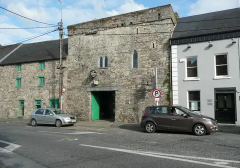
Tower House, Thomastown · Humphrey Bolton, CC BY-SA 2.0 via Wikimedia Commons Castle. On Low Street. In the centre.
- Opening hours
- Not on the map. Check before you go
- Admission
- Not recorded here. Ask at the door
- Position
- 52.5251° N, 7.1378° W
2 min walk · 130 m- 5 min walk · 370 m
- 3 min walk · 210 m
- 2 min walk · 130 m
- 5 min walk · 440 m
- 18 min walk · 1.4 km
- 34 min walk · 2.7 km

Each walk is routed over OpenStreetMap footpaths on this site’s own graph, and the minutes are that measured distance at 4.8 km an hour. That is a stated pace on level ground, not a promise about yours or about the hills in the way. Where the router finds no way on foot between two stops, the page says so and draws nothing: no walking time here is worked out from a straight line. Nothing here states an opening time or an admission price unless the map records it, because a wrong one ruins a day in a way a missing one does not: every stop links to the operator instead. Distances are within Thomastown.
How the day is shaped
Brady's Castle, Nicholas Mullins Bridge, Thomastown Concert Hall and Thomastown Church. 110 minutes in all.
The Yellow Gate, Upper Paddock Diversity Garden and Saint Columbkille's Well. 75 minutes in all.
Grennan Castle. 45 minutes in all.
Questions people ask
How long does thomastown in a day take?
Who chose these stops?
Are the opening times here?
What does it cost?
How do you get to Thomastown?
The order and the minutes were computed on 2026-09-20 by the rules above. Place locations and recorded opening hours come from OpenStreetMap. Researched visitor notes have their own sources linked on the cards. Check the venue for current admission and opening arrangements. Each walk is routed over OpenStreetMap footpaths on this site’s own graph, and the minutes are that measured distance at 4.8 km/h, which is a stated pace rather than a promise about yours.
Back to Thomastown·Everything to see in Thomastown·Getting to Thomastown