The Pikeman, Tralee
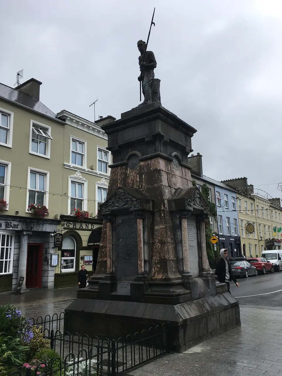
The Pikeman is a monument near Denny Street in Tralee, County Kerry, in the centre.
Erected by the Nationalists of Kerry to commemorate the heroes of 98 '03 48 and 67 and the other Irishmen who sacrificed their lives and liberties for Ireland
- Kind
- Monuments
- Nearest road
- Denny StreetThe closest named road, measured here. The map records no address for this place, so this is not a statement about where its door is.
- From the centre
- In the centre
- Parking
- Imperial Hotel Car Park, 60 m away
- Bus stop
- The Mall, 40 m away

Getting to The Pikeman
About these directions
Public transport times come from National Transport Authority. Timetables cover 2026-09-18 to 2027-09-19. These are scheduled services; check with the operator for cancellations and changes before travelling.
Walking and driving times are estimates. A town search starts at its centre; choose your location or a point on the map for a more precise starting point. Eircode search is not available.
How journey planning worksDestination, access and nearby stops
The Pikeman is in Tralee, County Kerry. Routes here end at the point the map records for this place. No entrance has been verified, so the last few metres are for you to judge. Imperial Hotel Car Park is 60 m away and the map records it as open to the public.
The nearest scheduled stop is Tralee Denny Street (11332), 170 m away in a straight line. Use the planner to check walking connections for your journey.
- Tralee Denny Street 170 m
bus 278Scheduled departures from this stop
- The Square 180 m
buses 290A and 290BScheduled departures from this stop
- Ashe Street 190 m
buses 290A and 290BScheduled departures from this stop
- N Circular Road 330 m
bus 290AScheduled departures from this stop
- Tralee Prnce's St 390 m
buses 275 and 273Scheduled departures from this stop
Getting to Tralee covers the journeys into the town itself.
Events nearby
Not at The Pikeman. These are at other venues within a few hundred metres of it.
- 15 October to 1 November 2026Free entrySamhain Chiarraí - A Kerry HalloweenKerry County
- 16 October to 6 November 2026Free entrySamhain Chiarraí: Fire Rituals6 venues
- 16 October 2026TicketedRory’s Stories: The Good Ol’ DaysSiamsa Tíre - Theatre & Arts Centre
- 17 to 18 October 2026TicketedThe Cable live at Siamsa TíreSiamsa Tíre - Theatre & Arts Centre
Within a short walk
What else the map names within four hundred metres of The Pikeman, on Denny Street and around it.
- 10 m
- Orbitus10 mSolicitors
- The Zipyard20 mTailor
- Kerry College - Town Centre Campus20 mEducational institution
- Harrison O’Dwyer Solicitors20 mSolicitors
- 20 m
Also on Denny Street
Denny Street carries 31 of the places the map names in Tralee.
- Imperial HotelHotels
- The Grand HotelHotels
- The Pikeman’s InnPubs
- The Park Georgian GuesthouseGuest houses
- Flower Power Cafe And DeliCafés
- Piarsaigh ParkParks
- Harrison O’Dwyer SolicitorsSolicitors
- The ZipyardTailor
- OrbitusSolicitors
- Kerry College - Admissions OfficeEducational institution
- Axa InsuranceInsurance
- KCYS TraleeCommunity centres
- Kerry College - Town Centre CampusEducational institution
- The KerrymanNewspaper
- Reen Financial ServicesInsurance
- KyotoRestaurants
- Susan Crean DentalDentists
- Philip O'Sullivan, SolicitorSolicitors
Other monuments in Tralee
Nearest to The Pikeman first, and the figure beside each one is how far it is from The Pikeman, in a straight line. Same point, same measure.
- The Diceman30 mDenny Street
- Indian Mutiny / 2nd Anglo Chinese War Memorial120 mCourthouse Lane
- Crimea Cannon and War Memorial150 mAshe Street
- Kerry Prisoners220 mIvy Terrace
- Pádraig Mac Piarais220 mIvy Terrace
- Sonny McCarthy Memorial300 mIvy Terrace
- Charles Kerins Monument530 mRae Street
- James Last Monument860 mBoherbee
- Civil War Memorial910 mGarryruth
- Footballers Statue2.1 kmClashlehane Roundabout
- 8.3 km
- 8.3 km
Questions people ask
Where is The Pikeman?
What are the opening hours of The Pikeman?
How far is The Pikeman from the centre of Tralee?
Are there other monuments near The Pikeman?
How do you get to The Pikeman without a car?
Where this comes from
- From the map
- The name, the kind of place, the address where the record carries one, and any website, phone or opening hours shown as recorded on the map are tags on OpenStreetMap node/12912471584, and can be corrected there.
- Worked out here
- Every distance, the nearest road where the record has no address, which car park and which stop are nearest, and the order of the lists are this site’s own calculations from those records. Distances are straight lines between two points, not walks along the footpaths, and the map will route the real walk on request. A mistake in any of this is a mistake here rather than on the map.