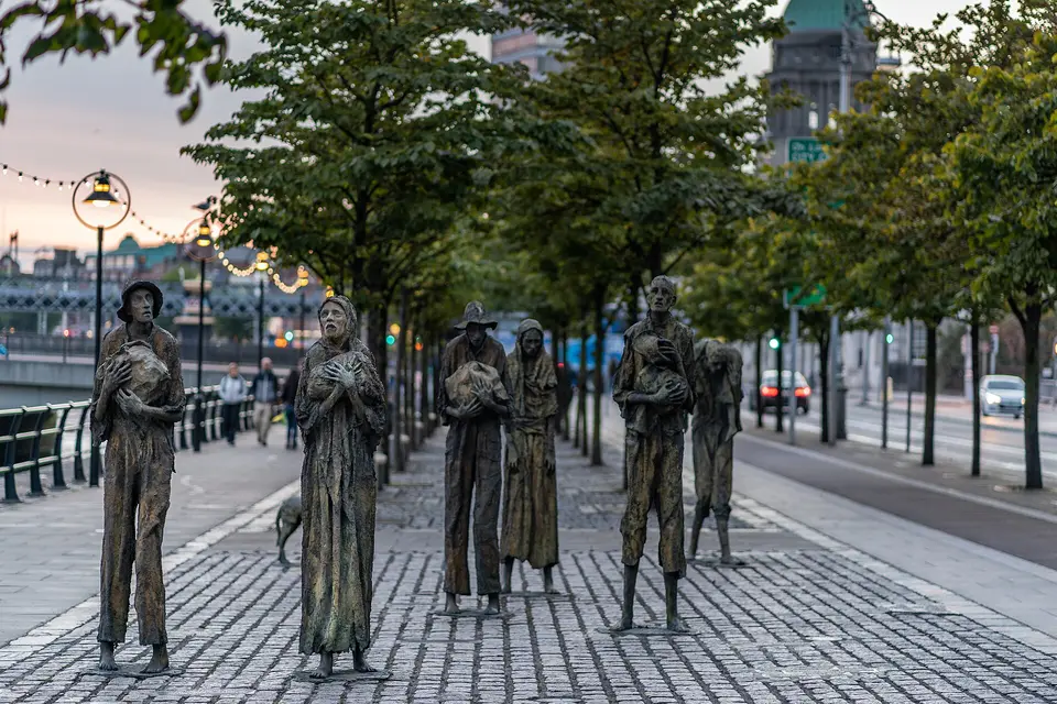
Famine Memorial, Dublin
Famine Memorial is a monument on Custom House Quay in Dublin, County Dublin, 720 m east of the centre. 17 October UN International Day for the Eradication of Poverty, George's Dock and Matt Talbot 1856-1925 are within 120 m.
The Famine Memorial, situated on the approach to Dublin port is a very poignant reminder of the number of Irish people that were forced to emigrate during famine times.
- Kind
- Monuments
- Address
- Custom House Quay
- From the centre
- 720 m east, in a straight line
- Wheelchair
- Recorded as accessibleOne tag covering the whole place. It does not say whether the entrance, the inside, the toilets or the route to the door are step free, and this page will not say so either.
- Dated
- 1997
- Parking
- City Quay Car Park, 130 m away
- Bus stop
- Georges Quay, 30 m away
_-_20180824203248.jpg)
Getting to Famine Memorial
About these directions
Public transport times come from National Transport Authority. Timetables cover 2026-09-18 to 2027-09-19. These are scheduled services; check with the operator for cancellations and changes before travelling.
Walking and driving times are estimates. A town search starts at its centre; choose your location or a point on the map for a more precise starting point. Eircode search is not available.
How journey planning worksDestination, access and nearby stops
Famine Memorial is in Dublin, County Dublin. Routes here end at the point the map records for this place. No entrance has been verified, so the last few metres are for you to judge. City Quay Car Park is 130 m away and the map records it as open to the public.
The nearest scheduled stop is IFSC (2498), 40 m away in a straight line. Use the planner to check walking connections for your journey.
- IFSC 40 m
buses G1, G2, 151, 60, 500 and 740 among othersScheduled departures from this stop
- George's Quay 160 m
bus 853Scheduled departures from this stop
- Moss Street 170 m
buses X28, X30, X27, P29, X25 and X26 among othersScheduled departures from this stop
- S O'Casey Br 190 m
buses 100X, G1, G2, 126, 151 and 120 among othersScheduled departures from this stop
- Busáras 220 m
buses 27, 14, H1, 130, H3 and H2 among othersScheduled departures from this stop
Getting to Dublin covers the journeys into the town itself.
Events nearby
Not at Famine Memorial. These are at other venues within a few hundred metres of it.
- 15 April to 17 October 2026TicketedDublin Port Behind-the-scenes Bus ToursMeeting Point: EPIC The Irish Emigration Museum
- 1 July to 31 December 2026Included with admissionEPIC Exhibition - Common Ground: Ireland in the EUEPIC The Irish Emigration Museum
- 18 October 2026TicketedThe Ramparts Live at The Abbey Theatre: 10 Year Anniversary ConcertAbbey Theatre
- 24 September to 26 November 2026TicketedDublin By Dusk at EPIC MuseumEPIC The Irish Emigration Museum
Within a short walk
What else the map names within four hundred metres of Famine Memorial, on Custom House Quay and around it.
- 40 m
- George's Dock80 mLakes
- As One120 mCafés
- Matt Talbot 1856-1925120 mMonuments
- TC Matthews120 mCarpet
- The Pig & Heifer120 mRestaurants
Also on Custom House Quay
Custom House Quay carries 19 of the places the map names in Dublin.
- StarbucksCafés
- Custom House QuayBike hire
- Custom HouseBike hire
- ely bar & brasserieBars
- TOSS'D Noodles & SaladsRestaurants
- InsomniaCafés
- IFSC PilatesGyms
- Seven WondersRestaurants
- Department of Housing, Local Government and HeritageGovernment offices
- EPIC The Irish Emigration MuseumMuseums
- BakehouseCafés
- Urban BrewingPubs
- Custom House Visitor CentreAttractions
- 17 October UN International Day for the Eradication of PovertyMonuments
- CHQShopping centres
- Hilton Garden Inn Dublin City CentreHotels
- Docklands Water Sports CentreSports centres
- George's DockLakes
Other monuments in Dublin
Nearest to Famine Memorial first, and the figure beside each one is how far it is from Famine Memorial, in a straight line. Same point, same measure.
- 17 October UN International Day for the Eradication of Poverty40 mCustom House Quay
- Matt Talbot 1856-1925120 mCity Quay
- Lost Seamen Monument180 mLombard Street East
- Elizabeth O'Farrell Park200 mLombard Street East
- 370 m
- 1974 Dublin and Monaghan Bombings Memorial380 mTalbot Street
- Phil Shanahan450 mJames Joyce Street
- The Naughten Institute450 mParade Ground
- Dublin and Monaghan Bombings460 mTalbot Street
- Humphrey Lloyd FRS470 mParade Ground
- Padraig Sheahan Memorial500 mHawkins Street
- The Irish National Flag: 155th Unveiling Anniversary500 mAbbey Street Lower
Questions people ask
Where is Famine Memorial?
What are the opening hours of Famine Memorial?
How far is Famine Memorial from the centre of Dublin?
Are there other monuments near Famine Memorial?
How do you get to Famine Memorial without a car?
Where this comes from
- From the map
- The name, the kind of place, the address where the record carries one, and any website, phone or opening hours shown as recorded on the map are tags on OpenStreetMap way/666422768, and can be corrected there.
- Worked out here
- Every distance, the nearest road where the record has no address, which car park and which stop are nearest, and the order of the lists are this site’s own calculations from those records. Distances are straight lines between two points, not walks along the footpaths, and the map will route the real walk on request. A mistake in any of this is a mistake here rather than on the map.