Dublin Castle, near Clonsilla
An important city landmark whose visitor closure needs planning around.
The story behind Dublin Castle
The castle served as a centre of English and later British administration until 1922. Much of the familiar complex consists of later state buildings rather than the original medieval fortress. The Record Tower preserves an older defensive presence beside the ceremonial spaces.
What you will see
Normally, the State Apartments and Chapel Royal provide the focus of a visit. They should not be treated as currently available attractions. Choose another castle interior while the public closure is in force.
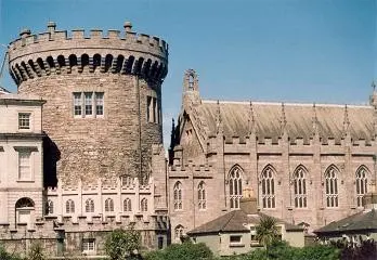

Resized and converted to WebP. Display may be cropped; the full photograph is linked.
Closed to visitors through 2026
The official notice closes public visits from 5 May to 31 December 2026 for Ireland’s EU Presidency. Older opening hours and ticket listings do not override that closure. Check the operator for reopening arrangements and any separately announced access.
Check the official visitor information ↗Sources and checks
- Office of Public WorksVisitor access and historical context. Checked .
- Fáilte IrelandHistorical context and visitor experience. Checked .
- Kind
- Castles
- Address
- Castle Street
- From Clonsilla
- 11 km south-east, in a straight line
- Run by
- Office of Public Works
- Wheelchair
- Recorded as partly accessibleOne tag covering the whole place. It does not say whether the entrance, the inside, the toilets or the route to the door are step free, and this page will not say so either.
- Dated
- ~1200
The map does not yet record a phone number for Dublin Castle. Anyone can add it on OpenStreetMap, and this page picks the change up at the next refresh.
Getting to Dublin Castle
About these directions
Public transport times come from National Transport Authority. Timetables cover 2026-09-18 to 2027-09-19. These are scheduled services; check with the operator for cancellations and changes before travelling.
Walking and driving times are estimates. A town search starts at its centre; choose your location or a point on the map for a more precise starting point. Eircode search is not available.
How journey planning worksDestination, access and nearby stops
Dublin Castle is in Clonsilla, County Dublin. Routes here end at the point the map records for this place. No entrance has been verified, so the last few metres are for you to judge.
The nearest scheduled stop is S Great George's St (1357), 50 m away in a straight line. Use the planner to check walking connections for your journey.
- S Great George's St 50 m
buses 16, 80, 122, 65B, 68 and 65 among othersScheduled departures from this stop
- Dame Street 140 m
buses 27, 77A, 151, 150, 56A and 77nScheduled departures from this stop
- College Green 200 m
buses 15, 14, 15B, 15A, 49n and 15DScheduled departures from this stop
- Lrd Edward St 240 m
bus 13Scheduled departures from this stop
- Parliament Street 240 m
bus 860Scheduled departures from this stop
Getting to Clonsilla covers the journeys into the town itself.
Events nearby
Not at Dublin Castle. These are at other venues within a few hundred metres of it.
- 10 September to 29 October 2026TicketedCrash Course On IrelandTurk's Head
- From 11 November 2025. Closing date to be confirmedFree entryLive Aid ExhibitionNational Photographic Archive
- 13 to 24 October 2026TicketedThe Man Who Swallowed a DictionarySmock Alley Theatre, 1662
- 14 to 15 October 2026TicketedRemember That Time? A MusicalSmock Alley Theatre, 1662
Other castles in Clonsilla
Nearest to Dublin Castle first, and the figure beside each one is how far it is from Dublin Castle, in a straight line. Same point, same measure.
- 4.9 km
- Ashtown Castle5.0 kmPhoenix Park
- 7.5 km
- 7.5 km
- 8.6 km
- 9.2 km
- 10.0 km
- Luttrellstown Castle12 kmWoodlands
- 15 km
- 19 km
- 22 km
- 22 km
Questions people ask
Where is Dublin Castle?
How do you contact Dublin Castle?
How far is Dublin Castle from the centre of Clonsilla?
Are there other castles near Dublin Castle?
How do you get to Dublin Castle without a car?
Where this comes from
- From the map
- The name, the kind of place, the address where the record carries one, and any website, phone or opening hours shown as recorded on the map are tags on OpenStreetMap way/350242806, and can be corrected there.
- Worked out here
- Every distance, the nearest road where the record has no address, which car park and which stop are nearest, and the order of the lists are this site’s own calculations from those records. Distances are straight lines between two points, not walks along the footpaths, and the map will route the real walk on request. A mistake in any of this is a mistake here rather than on the map.